Recent Articles
100th Anniversary of Three Sisters Radio Towers
At a period in the history of Arlington, Virginia, long ago, there was an area called Radio, Virginia. It was a neighborhood named for the old U.S. Navy Wireless Station in the vicinity of Columbia Pike and Courthouse Road.
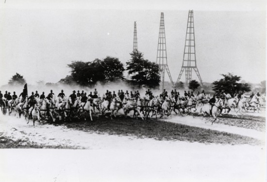
A trio of radio antennas – known to locals as “The Three Sisters’’ – towered over the neighborhood. In their day, the antenna towers were the world’s tallest. One of the towers was 45 feet taller than the Washington Monument. The Navy opened Radio Arlington, call sign NAA, in 1913, launching the U.S. military’s global communications system. A streetcar stop was even named “Radio.’’
Old Radio Arlington marked the first time the term “radio’’ was used in communications, according to Nan and Ross Netherton’s book “Arlington County in Virginia: A Pictorial History,” which was published in 1987. In the days of Marconi and other radio pioneers, the new communications mode was called “wireless telegraphy.’’
Eiffel Tower
Radio Arlington’s other firsts included a transoceanic radiotelephone circuit with a wireless station at the Eiffel Tower in 1915, and regular broadcasts of time signals, a service that helped ships at sea calibrate their navigational equipment.
While they may seem quaint or even primitive by modern standards, upon their completion in 1913, the Navy’s Radio Station Arlington Towers were considered to represent the height of cutting edge communications technology. In their day, “The Three Sisters” as they were known, were the second largest manmade structure in the world behind only the Eiffel Tower, with the tallest of the three standing a full 45 feet higher than the Washington Monument.
The towers were moved in 1941 because they were in the flight path for the newly opened Washington National Airport. The towers stand today at Annapolis Naval Acadamy in Maryland, on the edge of the Chesapeake Bay. The first time ‘radio’ was used to describe ‘wireless’ communications was when these towers were built and tested.
A Ham in the Family
 Forty years ago, singer and songwriter Jim Croce was enjoying new found success after signing a recording contract with ABC Records. Croce released two albums and several singles, including You Don’t Mess Around with Jim, Operator (That’s Not the Way It Feels), and Time in a Bottle. His biggest single Bad, Bad Leroy Brown hit number one on the American charts in July 1973.
Tragically, Croce died two months later, in September 1973, when the plane that was to take him from a performance in Louisiana to Texas on a concert tour crashed moments after take-off. Guitarist-songwriter Maury Muehleisen, who performed with Croce, and others, died in the crash. Croce left behind his wife Ingrid, a two-year-old son, and a number of hit songs that are still heard frequently today on radio stations across the country and available on CD and digital downloads.
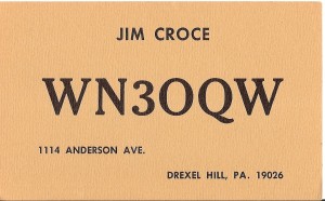 Through the years, some ham radio operators believed they contacted Croce in the 1970s when working WN3OQW of Drexel Hill, Pennsylvania, the town where Croce grew up. The name on the QSL card the operators treasured was indeed “Jim Croce” and the card bore the address 1114 Anderson Avenue, known to be the home of Croce’s parents.
However, in corresponding with Croce’s widow Ingrid, she reveals that WN3OQW was Jim Croce’s father. “James senior was the ham radio operator in the family,” Ingrid said. “Jim was the DJ at Villanova. He had a three hour Sunday night gig on WWVU.” More than a few hams who contacted WN3OQW then received the QSL card in the mail believed they had con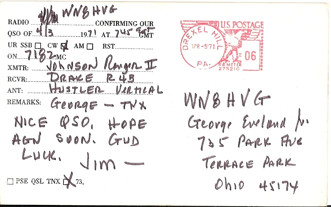 tacted the performer. But as Croce’s widow reveals, those hams instead had the privilege of working the man who gave us Croce and his timeless music.
George Eveland W8VG, formerly of Stafford, Virginia, contacted Croce’s father in 1971 and, as can be seen in the images in this article, still has a WN3OQW QSL card and his logbook showing the contact. “I was running a Drake 2C I’d gotten for Christmas in 1969,” said George, who was 14 at the time and held call sign WN8HVG. “That day was a Saturday and the contact was early, about 7:45 a.m. so I probably slid right out of bed and went straight to my radio shack, which was in the back corner of my bedroom on second floor of house,” George said. As can be seen on the reverse side of the senior Croce’s QSL card, Croce was running a Johnson Ranger II, Drake R4B receiver, and a Hustler vertical antenna. Eveland recalls listening to Jim Croce’s music during his teen years. “I remember sitting there during my senior year of high school listening to Operator, my favorite, and not being able to believe he was already gone,” he said.
Special thanks to George Eveland W8VG for sharing his logbook and QSL card images. QSL card & logbook images copyright © George Eveland W8VG. All rights reserved. A search of the U.S. Copyright database produced no registrations for the image of Jim Croce, which appears to be in the public domain.
QSONet delivers virtual ionosphere for amateur radio
QSONet is a good, timely resource for hams:

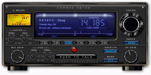
The Cormac Propadex – Current Ionospheric Conditions:
- Propadex is updated four times per hour
- Eight hours of history is shown on the graph.
- When the Propadex is high, it means the F2 maximum useable frequency is higher than average for this time of day.
 Technical Details:
- The Cormac Propadex is based entirely on the latest government reports for f0F2. This is the maximum useable frequency for the F2 ionosphere layer. Some government stations are updating this value 4 to 6 times per hour.
- The Propadex value is the DIFFERENCE between the latest reported f0F2 value and the 60 day average FOR THIS SAME TIME OF DAY.
- For example, if the Propadex shows as +110 at time 1700 Z, it means means the government monitoring station is reporting a maximum usable frequency 1.10 MHz higher than the 60 day average for this exact same time of day.
- Currently, we are obtaining data from the U.S. Air Force Radio Solar Telescope Network (RSTN) site at Wallops Island, Virginia. This site appears to be updating data several times per hour.
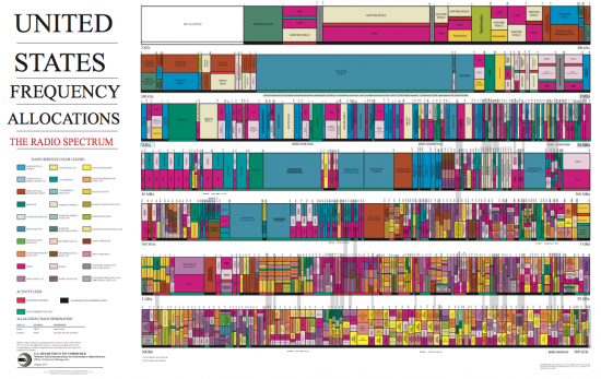
U.S. Frequency Allocations Wall Chart
Any ham knows that the radio spectrum is crowded. How crowded? Well, nothing drives home the point better than this PDF wall chart from the Department of Commerce. Click here to access the PDF.
Leisurely and impressive DXing on HF
The year 2012 comes to a close and it’s been a busy one. I’ve not been able to participate in regular RACES nets due to work commitments, but 2012 has been a successful time for “leisurely DX’ing.” I’ve finally lived in the same spot long enough to earn WAS and DXCC (Phone/Mixed) certificates using a modest HF station. And it only took about 30 years as a ham to get it done! 🙂
There are a few recent QSO’s that ARPSC members / readers may still be able to “snag”:
- Republic of South Sudan (Z81),
- Rodriguez I. (3B9),
- St. Peter and Paul I. (PT0S),
- Lesotho (7P),
- South Cook (E5/S), and
- Mauritania (5T).
 Other new entities worked (band specific) include: St. Helena I., Angola, Namibia, Saudi Arabia, Qatar, Gibraltar, Faroe Is, and Fernando de Noronha (PY0F).
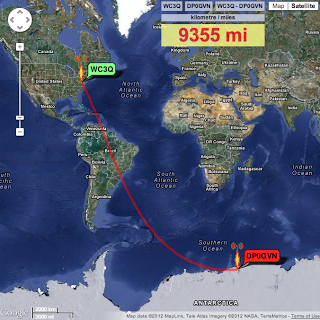
Perhaps the longest distance QSO’s were with stations on the continent of Antarctica … a mere 9000+ miles. DP0GVN / Neumayer III Station and KC4AAC / Palmer Station are often posted on the DX Cluster.
My station for DX’ing is fairly modest: FT-950, an HF amplified and an inverted HEX beam hanging from a 45′ high oak branch in our back yard. I’ve also started successfully working 40 and 75 meter DX using a long wire and a “Cage” antenna (75 meters).
You can read more about my DX adventures, my station, and antennas – along with posts on EmComm and my “DX Support Team” – by visiting http://wc3q.blogspot.com.
If you’re interested in DX or want to learn more, please drop an email. “DX Hot Spots” can also be tracked, as I work ’em, via real-time ClubLog Twitter posts for new entities as they’re worked (@wc3q).
Silent Key: Sean Smith, KG4WSS, Killed in Consulate Attack

Sean Smith, KG4WSS — shown here in his Facebook photo — was killed on September 11 in an attack on the US Consulate in Benghazi, Libya.
Sean P. Smith, KG4WSS, of Falls Church, Virginia, was killed when the US Consulate in Benghazi, Libya, was attacked on September 11. He was 34. Smith was one of four Americans, including Chris Stevens — the US Ambassador to Libya — who was killed in the attack.
Smith, a native of San Diego, enlisted in the Air Force in 1995 at age 17. He served six years as a ground radio maintenance specialist, including a deployment to Oman, before leaving the service in 2002 as a staff sergeant. He was awarded the Air Force Commendation Medal.
Smith, who had worked at the State Department for 10 years, was in Libya on a temporary assignment when he was killed. Prior to his temporary assignment to Benghazi, Smith served for the State Department in Brussels, Baghdad, Pretoria, Montreal and The Hague.
(story credit: ARRL.org)


